0
Banner Tay Bac 2015
Banner Dong Bac 2015
Banner Bac bo 2015
Banner Trung bo 2015
Banner Tay nguyen 2015
Banner Nam bo 2015
Sort:
18/06/2015, 11:29:59 / 42 Photo
Map

Mai Son Landscapes

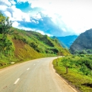
Son La is province of mountainous northwestern Vietnam, the province has an area of 14,125 km2 and ranks 3rd in the 63 provinces. Geographic Coordinates 20039 ' - 22002 ' north latitude and 103 011 ' - 105 002 ' east longitude. Boundaries: north border of the provinces of Yen Bai, Dien Bien, Lai Chau; east of Phu Tho, Hoa Binh; west of Dien Bien province; adjacent to the south and Thanh Hoa Province 's Democratic Republic of Lao People with long common border of 250 km, the length bordering other provinces is 628 km. Son La has 11 administrative units (1 city, 10 districts) with 12 ethnic groups. Most of today's Son La province (including Son La city, Moc Chau, Yen Chau, Mai Son, Song Ma, Thuan Chau) before 1479 as the kingdom's territory Tank Man (including Tuong Duong, Ky Son of Nghe An, Quan Hoa, Quan Son, Muong Lat of Thanh Hoa , Hua Phan of Laos and Son La province. 

Mai Son Landscape 01
Mai Son Landscape 02
Mai Son Landscape 24
Mai Son Landscape 03
Mai Son Landscape 04
Mai Son Landscape 05
Mai Son Landscape 06
Mai Son Landscape 07
Mai Son Landscape 08
Mai Son Landscape 09
Mai Son Landscape 10
Mai Son Landscape 11
Mai Son Landscape 12
Mai Son Landscape 13
Mai Son Landscape 14
Mai Son Landscape 15
Mai Son Landscape 16
Mai Son Landscape 17
Mai Son Landscape 18
Mai Son Landscape 19
Mai Son Landscape 20
Mai Son Landscape 21
Mai Son Landscape 22
Mai Son Landscape 23
Mai Son Landscape 25
Mai Son Landscape 26
Mai Son Landscape 27
Mai Son Landscape 28
Mai Son Landscape 29
Mai Son Landscape 30
Mai Son Landscape 31
Mai Son Landscape 32
Mai Son Landscape 33
Mai Son Landscape 34
Mai Son Landscape 35
Mai Son Landscape 36
Mai Son Landscape 37
Mai Son Landscape 38
Mai Son Landscape 39
Mai Son Landscape 40
Mai Son Landscape 41
Mai Son Landscape 42
tonyphamtran
Value Sharing - Ranking Assertion